GIS Data Solutions
High-Quality, Actionable Terrain Data for Critical Analyses
HII’s geospatial data solutions deliver high-fidelity terrain and vector data to support RF analysis, modeling and mission-critical decision-making. Using a proprietary ingesting and processing approach, raw LiDAR data is converted into usable, high-quality formats with rigorous editing to correct erroneous data points. The result is reliable, accurate geospatial data ready for actionable analyses in defense, telecommunications and spectrum optimization environments.
HII’s geospatial experts gather the best available terrain and vector data from a myriad of sources by converting raw LiDAR data in combination with a robust quality assurance process by employing multiple LiDAR and geospatial editing software packages that enable teams to correct erroneous data points within the raw data files, providing the end user with high quality data that is ready for actionable analyses.
Mission Applications
- Terrain-informed RF propagation modeling and analysis.
- Electromagnetic interference (EMI) prediction and mitigation.
- Spectrum optimization for congested or contested environments.
- Network performance evaluation and planning.
- High-resolution terrain modeling for defense and commercial operations.
- Rapid large-scale data sourcing to support time-sensitive missions.
100+ terabytes of geospatial data with coverage ranging from 10⁻¹ meters across the continental United States
Advantages
Accurate predictions: Highly accurate predictions of RF signal loss over variable terrain and sea water help optimize communication systems for maximum performance.
Wide applicability: Suitable for both ground-based and airborne transmitters and receivers make it a versatile tool for various applications.
Government-approved: The de facto propagation tool of the United States Federal Government ensures its reliability and credibility in predicting RF signal loss.
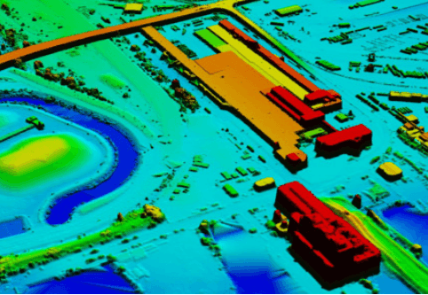
Same Location, Different Resolution:
Specifications
| Data Processing | GIS data utilizing geospatial software packages including Python, GDAL, ArcGIS Desktop, ArcGIS Pro, QT Modeler, LP360, and QGIS and several custom tools and scripts utilizing Python and GDAL to aid in the data processing and conversion. |
| Data Formats | LAS, LAZ, TIF, PY, DT1, DT2, GeoJSON, SHP, XLS, CSV, PRJ, KML and ANSII. |
| Available Data Sets | 10m coverage of the continental US and several territories. 5m data for Hawaii and the Majority of the continental US. 1m coverage of Maryland, Delaware, Virginia, Alabama, Florida, North Caroline, South Carolina, and New York with partial 1m coverage of Arizona, Colorado, West Virginia, Vermont, Hawaii, and Alaska. OCONUS coverage available by request. |
HII Awarded $84M Contract to Support National Geospatial Agency’s Enterprise Cloud Migration

MCLEAN, Va., (July 11, 2023) — HII (NYSE: HII) announced today that its Mission Technologies division was awarded an $84 million contract to continue supporting the National Geospatial Agency’s (NGA) IT enterprise cloud migration. The recompeted contract was awarded under the Department of Defense Information Analysis Center’s (DoDIAC) multiple-award contract (MAC) vehicle by the U.S. Air Force's 774th Enterprise Sourcing Squadron. It has a term of five years.